The Fourth-Grader Speaks of Rivers
And of canals, estuaries, and saltwater lagoons.
I never questioned anything a teacher told me until the fourth grade. In the Sunshine State, fourth-graders study Florida history. We learn about Ponce de Leon’s search for the Fountain of Youth. If we are lucky, we participate in a field trip to St. Augustine. During our studies, we learn about the St. Johns River, which has its source near the Everglades and flows along Florida’s Atlantic coast. For many miles, the St. Johns runs parallel to the Indian River, which is not a river but a saltwater lagoon that connects to the Banana River, which is also not a river and has nothing to do with bananas. The St. Johns meets the Atlantic Ocean east of Jacksonville, about 310 miles north of its marshy headwaters. The Nile and the St. John’s River, our teachers told us, are the only two rivers in the world that flow north. At my school, this was considered conventional knowledge.
This is where I became suspicious. I found it difficult to believe that, in the entire world, no other rivers flowed north. Our school library housed a large globe. Normally, the purpose of an elementary school globe is for kids to spin it really fast, put their finger on it, and find out, by wherever they touch when the globe stops, where they will live as an adult—which is usually Siberia or somewhere in the middle of the Pacific Ocean. But for me, on that particular day, the globe served the more noble purpose of helping me prove my teachers wrong.
If you look at the northern shores of any continent, you’ll find rebellious rivers that defy the authority of fourth-grade teachers by flowing north. South America’s Magdalena River slices through the heart of Colombia before spilling into the Caribbean Sea north of the town of Barranquilla. The Courantyne River forms the border between Suriname and Guyana, and it runs roughly parallel to the northward-flowing Essequibo River. In North America, the Moose River flows generally northward and meets the Hudson Bay on its southern shore, as does the Harricana River. Three great Asian rivers, the Lena, the Ob, and the Yenisey, each flow more than 2,500 miles northward through the Siberian tundra (where I had recently learned I would live as an adult) and spill into the Arctic Ocean.
According to my distant and foggy memory, when I showed my teacher the rivers I had identified, she scowled at the globe, glowered at me, and walked away. I learned that people don’t like being told they are wrong—especially by a fourth-grader.
Not long ago, while cruising the Indian River on a friend’s boat, we started discussing how the Indian River is a lagoon and not a river, and I mentioned disputing my fourth-grade teacher’s claim that the St. Johns and the Nile, the world’s longest river, were the only two rivers in the world that flowed north. My friend’s daughter, a delightfully precocious fourth-grader, informed me that the Nile was not the longest river in the world. The Amazon, she said, was longer. Incredulous, I looked it up.
An article on the website Explorers Web states that “Conventional knowledge holds that the Nile … is the world’s longest river. But some dispute this, because there is no scientific consensus about where the rivers start.” In 1996, the article notes, an expedition of the Royal Geographic Society added the length of a feeder stream called Apacheta Creek to the length of a tributary river called the Apurimac, thus stretching the measure of the Amazon by 593 kilometers, making it longer than the Nile.
In 2014, the Royal Geographical Society published a paper that proposed an alternate source for the Amazon, and it invoked a debate over whether the source of a river must be perennial, existing year-round, or ephemeral, indicating a portion of a river is dry in parts of the year. The abstract of the paper, which “do[es] not necessarily reflect the opinion of the Royal Geographical Society,” notes that the Amazon River is “the longest or second longest.” The Encyclopedia Britannica and the Guinness Book of World Records, however, both recognize the Nile as the longest river in the world. Of the two authorities, only Guinness acknowledges the dispute.
The length of a river is hardly its most interesting characteristic—especially compared with the wildlife that exists in and around its watershed, the commerce that moves up and down its current, and the civilizations that have risen and fallen along its banks. A fourth-grader may know the length of a river, and how it ranks in the pantheon of world rivers, but it’s the people who work and live on a river who know it best—the river pilot who navigates its curves, the fishermen who troll the waters, and the ancient farmers who counted on the annual flood to irrigate their crops.
Harlem Renaissance writer Langston Hughes wrote about rivers. He evoked the importance of many of the world’s great rivers to the heritage of Black culture. “I’ve known rivers ancient as the world and older than the flow of human blood in human veins,” Hughes writes. He evokes the Tigris and Euphrates. The Nile. “I heard the singing of the Mississippi when Abe Lincoln went down to New Orleans, and I’ve seen its muddy bosom turn all golden in the sunset.” Hughes concludes: “My soul has grown deep like the rivers.” Langston Hughes had a spiritual connection with rivers. He never mentioned how long any of them were, or in which direction they flowed.
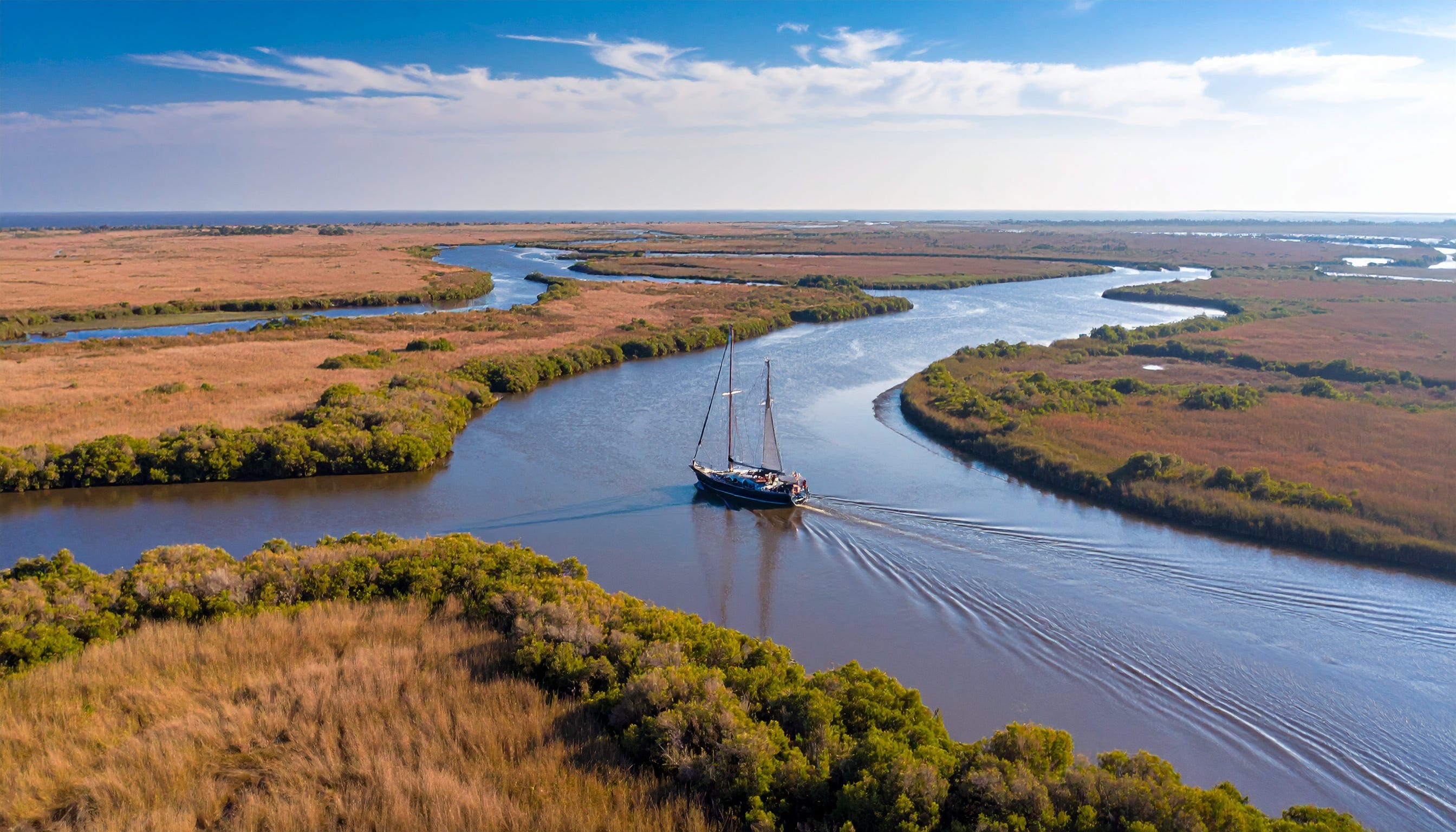
The rivers I know best are Florida’s Caloosahatchee and St. Lucie rivers, which, as part of the Okeechobee Waterway, connect the Gulf of Mexico to the Atlantic Ocean. I transited the waterway years ago on a 34-foot sailboat.
The Caloosahatchee spills into Charlotte Harbor near Ft. Myers, on Florida’s southwest coast. For miles, it’s a broad estuary. Private homes line the banks. Several bridges arc across the channel, and although I knew they were probably tall enough to accommodate my 38-foot mast, the markers designed to indicate the clearance had faded, so I closed my eyes each time I entered the shadow of a span, hoping it would not rip the mast from my boat.
East of Interstate 75, the Caloosahatchee narrows, and the banks become more rugged and less populated. The influence of saltwater and ocean tides vanish. The water smells of farming and industry. Rusty barges share the narrow channel. Somewhere around the town of LaBelle, the Caloosahatchee River becomes the Caloosahatchee Canal. You know you’re in a canal by the long straight stretches, which are punctuated by angular corners. Engineers dig ditches. Rivers, by contrast, curve and meander with the contours of the land.
The canal leads to Lake Okeechobee, which is rimmed by tall levees, so for miles you can sense you’re in the presence of a large body of fresh water, but you cannot see it. In the little town of Clewiston, I ate disappointing lasagna and spent the night tied to a dock, floating on dark water just deep enough to accommodate my keel. The next day, I ventured across Lake Okeechobee. On a hazy day, in the middle of the big water, you cannot see land. It’s like being in the middle of a shallow sea that is swarming with alligators.
At Port Mayaca, you must pass through hydraulic locks, which step you down into the St. Lucie canal. There, you encounter an ancient railroad lift bridge, notorious for being just a little too short for some sailboats making the passage. I barely squeezed through—with my eyes shut—thanks to the record drought conditions that left the water low, and the canal’s banks sandy and bare.
Eventually, the long straightaways and angular corners give way to the gentle curving banks of the St. Lucie River, which, due to the excessive engineering of the Okeechobee Waterway, is really an estuary, which is commonly considered part of the Indian River, which of course you know by now, is not a river, but a saltwater lagoon. I have no idea how long it is.